FSC forest management certification, which is based on the on-site evaluation of forest management units, now certifies the standard of forest management on over 150 million hectares of forestry.
The recent rapid expansion in area certified has led to concerns on quality standards. For large scale and complex forests, current certification methodologies provide no spatial information on the range of forests set within the broader context of land use planning, especially where the landscape concerned is highly heterogeneous. This is a particular problem in mega operations which often cover millions of hectares where physical access to the more remote and inaccessible operational areas for inspections teams are limited by the level of audit fee. In addition, the availability of temporally and spatially accurate data and records vary from audit to audit. Furthermore, audit teams rely almost exclusively on data and information provided by the forest management and auditors have little opportunity to access data independently.
FSC has identified these limitations to conventional certification procedures and believe any opportunity to mitigate these risks to the quality of certificates issued, increase transparency and access to the audit process to the broader stakeholder community which does not reduce the overall cost effectiveness of certification, has to be fully investigated.
For the last 5 years, the Earth Observation Market Development arm of the European Space Agency (ESA) has been sponsoring a series of projects which progressively analysed the data needs of the Forest Stewardship Council (FSC) and its stakeholders in delivering certification services on forestry operations and potential for Earth Observation (EO) to deliver that spatial data in a way that would improve the standard of certification. This led to a large scale development project which demonstrated a range of EO products across three widely different forest regions of the world. The results of these studies were delivered to FSC stakeholders over the last two FSC General Assemblies.
TransparentForests
A consortium, including FSC, has prepared a proposal which is under consideration for funding by ESA within the Integrated Applications Programme of European Space Research and Technology Centre (ESTEC), to undertake a feasibility study for the design and development of TransparentForests, a web based certification information system that would address the above concerns. The project's first step will be to engage the key stakeholder groups within FSC (this would include FSC as the parent organisation and its accreditation body Accreditation Standards International, the Certification Bodies and the Certification Bodies' clients, the Forestry Organisations) in a process to develop the specification of the content and services of TransparentForests. Other stakeholders such as the key NGOs and forest communities will be consulted on how such a system could help them with respect to forest data transparency and access.
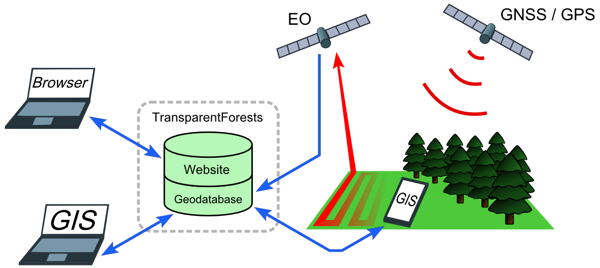
Having established the operational and cost baseline for conventional certification and the key design features of TransparentForests, the consortium will develop a prototype of the TransparentForests web-based service featuring a geospatial database used to centrally store independently generated customised EO products and associated layers of forest management information required for certification (e.g. boundaries and protected areas). The web based service will be supported by a number of tailor-made GIS toolkits enabling data review and analysis by audit teams and the integration of the EO maps and other derived data into certification reports, increasing the transparency and quality of the certification process.
The costs and benefits of the resulting prototype to the key user groups will be analysed. Based on an analysis of several different implementation scenarios, FSC will be able to evaluate the benefits of TransparentForests as a tool to underpin its services and to maintain leadership within this sector.
The Consortium
The consortium is made up of 5 specialist service providers.
Eyre Consulting (www.eyreconsulting.co.uk) will have overall project management responsibility and will undertake the collection and analysis of cost benefit data. sarmap SA (www.sarmap.ch) and Environment Systems (www.envsys.co.uk) specialise in the design and integration of EO products as services for forestry and agriculture sectors. Lutra Consulting have developed web-based platforms similar to TransparentForests for other clients and is responsible for the design and development of all web and desktop based GIS tools, all of which will be developed using open source software, maximising access for all FSC stakeholders. Finally the University of Nottingham (www.nottingham.ac.uk/grace) will be responsible for advising on the accuracy and integration of data derived from satellite navigation and positioning systems.
Alongside this technical team, FSC (www.fsc.org) as the industry partner, provides access to its stakeholders, guidance on its needs and ultimately, the assessment of the benefits of TransparentForests. FSC and its stakeholders will consider the next phase of this process, the full scale development of TransparentForests, within a demonstration project at the conclusion of this Feasibility Study phase.
e-Brochure
Click here to download the ESA project e-Brochure.
Project Timeline
The TransparentForests Feasibility Study will start in January 2013 and is due to be completed in October 2013.
Further Information
Please contact either Charles Crosthwaite Eyre (charles.eyre@eyreconsulting.co.uk) or, for FSC, Tim Synnott (timsynnott@prodigy.net.mx) for further information on the project.
Update 10/02/2014
The feasibility study has now been successfully completed and a small write-up can be found here.
You may also like...
Mergin Maps, a field data collection app based on QGIS. Mergin Maps makes field work easy with its simple interface and cloud-based sync. Available on Android, iOS and Windows.