Back in April 2025, we launched an ambitious crowdfunding campaign: bringing professional-grade 3D and digital twin capabilities to QGIS. The goal was to transform QGIS into a serious open-source platform for digital twins, closing the gap with expensive proprietary alternatives.
We are thrilled to share the results. The campaign was fully funded, the work is almost completed and the vast majority of features are already live. In this article and following blog posts, we will summarise the features with a full tour of what was delivered across QGIS 4.0 and what is still landing in the upcoming QGIS 4.2.
Cities, infrastructure networks, utilities, and environmental systems are increasingly managed through digital twins: live, data-rich 3D models that mirror the real world. Until now, this space has been dominated by expensive, closed-source platforms.
Our campaign, delivered in collaboration with North Road, set out to change that. We aimed to improve QGIS to become a platform with high-performance rendering, industry-standard data formats, powerful point cloud tools, and immersive visualisation.
The community supported the vision. Watch this space for upcoming posts detailing the enhanced capabilities and tools in QGIS thanks to your generous support of this campaign.
One of the most important interoperability features in the campaign: a native I3S data provider.
ESRI’s I3S (Indexed 3D Scene Layers) is one of the OGC standard formats for 3D city models and digital twin datasets built on ArcGIS. QGIS now supports:
This new feature essentially extends the current ArcGIS Rest Servers data provider to support the ESRI 3D scene layer. To add a new scene layer, you can visit ArcGIS Living Atlas and search for a location and filter by Layer Type: Scene Layer. Click on a result, scroll down to the URL section on the item details page, and copy the link.
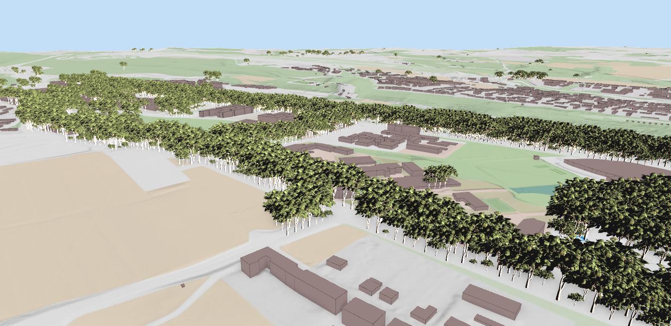
For example, we are going to use https://tiles.arcgis.com/tiles/oPre3pOfRfefL8y0/arcgis/rest/services which contains buildings and terrain data for Switzerland:


Once you add the data in QGIS, you should be able to see the buildings’ footprints in the 2D map view. In the image below, I have added other data from Swisstopo for more context:

As the data are 3D, you should be able to view it also in 3D map view:

QGIS also supports textured I3S layers, streaming building meshes complete with photogrammetry-derived textures:
Rendering complex 3D data demands significant hardware resources, specifically a capable GPU and ample RAM. QGIS defaults to a 500MB memory limit per layer, which may cause performance issues with high-resolution assets like the Frankfurt Scene Server. To resolve memory warnings and accelerate rendering, navigate to Settings > Options > 3D and increase the graphics memory to 1000MB or 2000MB.
We would like to extend our thanks to the donors whose generous support made this work on digital twins for QGIS possible: Summit Aeroworks, Mission North, Drone Agri Tech, Gabriel Diosan, Lint Geospatial, EXeIdea Ltd, Charles Beaudry, GisVis, Ashwin Nair Anil Kumar, Phillip Zakas, City of Vevey, QWAST-GIS, 12P Consulting, Dieter Todeskino, Gerard Bufort, Maxence Ballif, Sravan Kumar, SenseRemote, Richard McBride, Tandon Urban Solution Pvt Ltd, Estudios Técnicos Inc., Karl-Erik Wilson, Corinne Hermle, Right Place Geo, Canton de Neuchâtel, Wing Environmental Modeling Consultancy, Vedran Stojnović, Fischer Teamplan Ing.-Büro GmbH, Geoff Wright, ALMA Consult, Pierre Assali, Wanderfeast LLC, QTIBIA Engineering, QGIS Danish Usergroup, Matthias Schramm, Ecophylla Consulting, Peter Minadi, Wooserk Park, Afritech Geoscience Limited UK, SURFaCE LIBRE, CityStructure, Andreas Neumann, Västra Götalandsregionen, QGIS Slovakia, Soluciones GeoEspaciales SAS, Mihail-Alexandru Neculai, Wald- und Umweltplanung, Ville de Nyon, Chinook Landscape Architecture, Frontier Waste Solutions, Bill Williamson, QGIS User Group Switzerland, QGIS Sweden User Group, Stadt Dornbirn, Stadt Minden, IGN FI, Humanitarian.IM, Earth Digital Systems, Eunsook Jeong, Suncrops Ltd., Kanton Appenzell Innerrhoden, Jill Spreeuw-Kasanwidjojo, National Land Survey of Finland, Kanton Schaffhausen. We are also deeply grateful to those who contributed anonymously - your support is no less valued and was equally essential in bringing this project to life.
This concludes part one of our tour. Follow us for next week’s post to see how these crowdfunding results are further transforming the QGIS ecosystem.
Let's make the QGIS work for you
Lutra Consulting is a QGIS-focused expert provider of geospatial software development, consulting, training, and support services.