
Amount pledged:
1
EUR
Target amount:
85000
EUR
Campaign end:
7th December 2026
After our five successful crowdfunding campaigns to push QGIS 3D further ahead, we are back with a new campaign to bring working with 3D data in QGIS to yet another level. This time, the main theme is to bring a state of the art reality capture technology to QGIS, along with a major upgrade to the animation support. But that’s not all - we also plan to add atmospheric scattering for more realistic looking 3D scenes, scene presets, close various gaps in the identify tool and add support for gamepads for easier navigation!
The total cost of development will be 85 000 EUR. If you want to make a contribution, please fill in the pledge form. For more information about contribution and how it works, see below.
The campaign to pledge funds is set to finish on December 7, 2026. Work will commence when the target for our crowdfunding campaign has been reached. We aim to deliver the promised features over QGIS releases in 2027 (versions 4.6, 4.8 and 4.10).
This effort has been organised and led by Lutra Consulting in collaboration with North Road. These are two highly respected, proven companies committed to open source GIS, both of them with a history of running successful campaigns to enhance Open Source GIS software.

Together, we’ve put forward a team of outstanding quality and complementary skills:
This project cannot go ahead without your support! We use crowdfunding to raise funds for projects like this one which benefit a wide community of users. The project will only proceed if sufficient funding can be raised before the project crowdfunding deadline.
Pledging funds is safe and easy. Simply fill in the pledge form to state how much you want to pledge - pledges only become binding if the funding target is reached before the deadline. When we reach the target, we will send invoices to supporters and the implementation work will start. The minimum amount to contribute is set to 200 euro. If you cannot afford to make a financial contribution, we appreciate it if you could spread the word.
For any questions, please do not hesitate to contact Saber.
If you are based in Australia and have difficulty pledging funds to companies outside your country, please contact North Road to facilitate your contribution.
If your organization cannot contribute to a crowdfunding campaign and you would like to arrange a private contract to cover some of the features, please contact us.
3D Gaussian Splatting is a new reality capture technique introduced in 2023, and it has sparked a lot of excitement. It represents a 3D scene not as a triangular mesh, but as a large collection of 3D Gaussians (ellipsoids) parameterized by position, scale, rotation, color, and opacity. These individual Gaussians are optimized to accurately reproduce the scene from various input images. As a result, one can get high-quality 3D models that can be rendered in real time efficiently.
This is very exciting for geospatial applications - it captures visual appearance of both man-made and natural environments more realistically than traditional 3D mesh models from photogrammetry. Traditional photogrammetry has lots of issues with representation of objects that have complex geometry, thin objects, semi-transparent or reflective objects.

If you have not tried Gaussian Splatting before, try some scans hosted online: of the existing Budapest parliament or Atomium - each with ~1 million splats, or the large scale scan of Jastrzębia Góra with ~100 million splats.
If you are interested in how Gaussian Splatting works under the hood, check out this video: How Gaussian Splatting Is Changing 3D Rendering
To produce a Gaussian Splatting model, one needs a set of RGB images of an area of interest. Using those, there are both open source (e.g. Brush, NerfStudio, OpenSplat) and proprietary tools (e.g. Postshot, Pix4D, Kiri Engine, Esri) to create 3DGS datasets.
Here’s a reality capture from our experiments - we flew a mission with a DJI Mini 5 Pro drone over a small area of interest where we took 112 pictures. Then we used open source tools (COLMAP and Brush) to train a 3D scene from the image and did a bit of cropping of the scene using the Supersplat editor. Here’s a little animation of our result, with nearly 3 million splats:
Now imagine being able to open this kind of data in QGIS, have such scans overlaid with the rest of your geospatial data in 2D and 3D map canvas! That’s exactly what we’d like to do.
There are several file formats for Gaussian Splatting, with various capabilities when it comes to support of compression, large scenes or streaming. Cesium, Esri and other companies have been working together to extend 3D Tiles for Gaussian Splatting - and we will also use the KHR_gaussian_splatting extension that came out of their joint efforts for standardization.
The implementation in QGIS would be based on top of the tiled scene layers, which have been introduced back in 2023 by Lutra Consulting and North Road. Tiled scene layers support 3D Tiles standard and Esri’s scene layers (I3S) - in both cases currently only triangular mesh models. Within the proposed work, we will add parsing of the 3DGS data encoded as 3D Tiles, and rendering techniques for both 2D and 3D map views to display the data.
QGIS 4.2 saw the introduction of major improvements to the appearance of QGIS 3D scenes. These include a completely re-worked shadow engine, a fully HDR compliant rendering pipeline, enhanced materials setup for more accurate rendering, and optional bloom effects to better convey bright lighting in a scene. This release also added support for “environmental lighting” effects, where a user can configure a skybox to render scene backgrounds, which display as physically accurate reflections on objects in the scene.
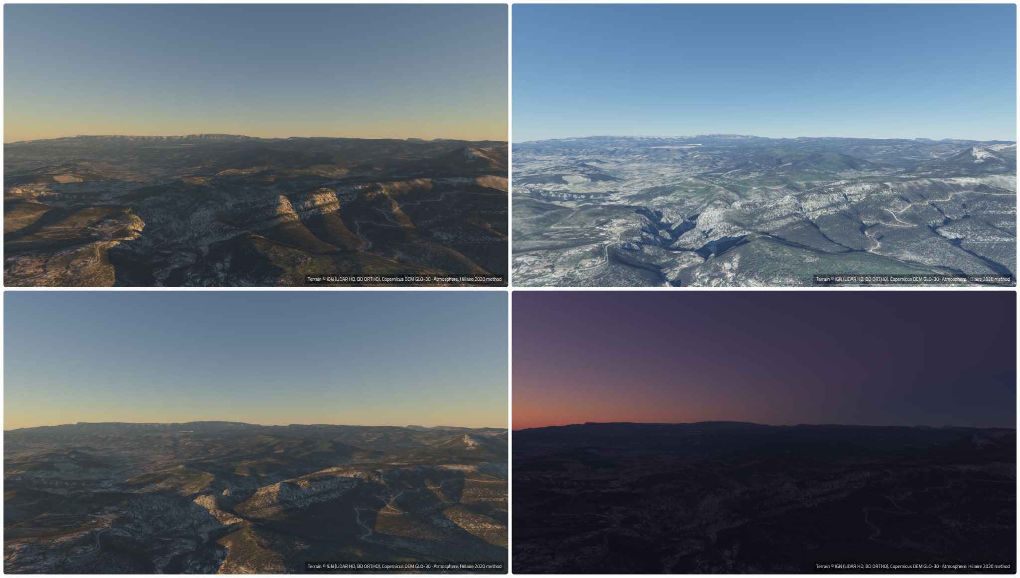
These environmental lighting effects still require the user to find and set up an appropriate skybox for their scenes. To make this both easier for users and for better quality and accurate sky effects, we will introduce automated atmosphere effects. The atmosphere will be modeled to respect the scene’s time of day, allowing for scenes which reflect dawn, midday, dusk or nighttime lighting.
Additionally, the impact of atmospheric scattering will also be included, causing more distant objects in the scene to fade in a realistic way. This isn’t just a nice visual effect, but rather it helps users immediately and intuitively understand the depth and relative distances within the scene.
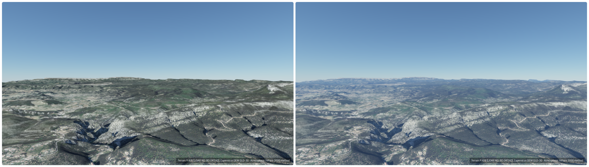
The modeling will follow the approach pioneered by Sébastien Hillaire, described in his paper from 2020.
Additionally, the modeled atmosphere will also generate environmental lighting, so that reflective materials in the scene will correctly follow the lighting of the atmosphere.
This new feature will allow users to easily create beautiful, realistic 3D scenes directly within QGIS.
We recognise that there’s multiple use cases for 3D maps in QGIS, and that not all users or applications benefit from realistic looking scenes. For instance, when QGIS is used to display BIM or CAD data, it’s often preferable for the scene’s appearance to instead be configured for clearest display of the spatial objects and their attributes, and that in these situations shadows and realistic lighting effects may be detrimental to the map.
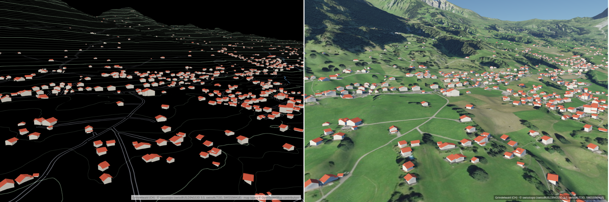
To nicely handle both these use cases, we will add a concept of “scene presets” for QGIS 3D maps. Specifically, they will have a choice of:
The choice of preset will impact the initial settings for the scene only – users will still be able to manually reconfigure existing scenes and fine-tune these settings as desired.
Creating animations of 3D maps in existing QGIS versions can be a fiddly, frustrating process. We realise that there’s a need for improving this drastically! We also realise that some users have a desire to create animated versions of their 2D maps. In this project we will address both use cases, by introducing a flexible animation system which can be used for both 2D and 3D maps.
The new framework will allow users to create independent keyframes for different map properties, and control exactly where these keyframes occur and how interpolation should be done between keyframes (on a keyframe by keyframe basis).
For example, a 2D map animation may have independent keyframes for the map scale at certain frames, and keyframes for map rotation (or map center x/y) at different times. A 3D map can have independent keyframes set for the camera focal point x/y, and the camera zoom at others.
The keyframes will be configured using a brand new, user-friendly widget, based on standard interfaces exposed by other animation and video editing software.
Additionally, users will have the ability to automatically generate keyframes based on standard animation templates. For instance, at a certain point in their 3D map animation, they could automatically generate and insert keyframes which cause the camera to orbit around its focal point. We will add a number of common animation presets for insertion in this way, e.g. allowing camera orbits or 360 degree pans.
Finally, we will introduce a native means to generate video exports directly from within QGIS, avoiding the current need for users to manually stitch together exported image frames in an external application.
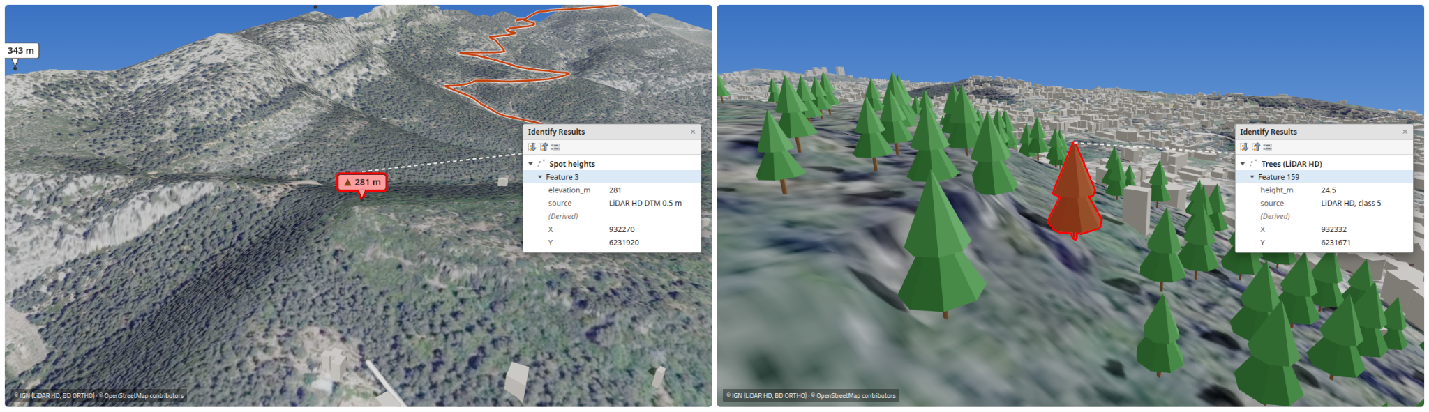
Identification of objects in 3D map views is one of the key features in a 3D map viewer. While this works well for vector layers with polygon geometries, there are some functionality gaps with line and especially point geometries - and such features do not get identified and highlighted in 3D views. We would like to fix that, and implement identification and highlight of points shown as billboards, basic 3D shapes or as custom 3D models, as well as support for line geometries when rendered as simple lines.
To help users intuitively navigate through their 3D scenes, we’ll be adding support for using gamepads for control. This will unlock control via Playstation Dual Sense controllers, XBox controllers, or other third party gamepads. These devices have been designed for rapid but precise movement through 3D scenes, and our testing has shown that using them to move through a 3D map is much simpler than using a traditional keyboard/mouse combination.
We’ll introduce some simple settings to allow users to pick which connected gamepad to use for map control, and adjust options such as the controller sensitivity and button mapping. Note that support for individual hardware and availability of this functionality will vary depending on the user’s platform and desktop environment.
The page contains data from the following sources:
Elevation data for the atmospheric scattering images: Copernicus DEM GLO-30, © DLR e.V. 2010–2014 and © Airbus Defence and Space GmbH 2014–2018, provided under COPERNICUS by the European Union and ESA. All rights reserved.
Contains data from IGN (Institut national de l'information géographique et forestière): LiDAR HD and BD ORTHO, 2024–2025, Licence Ouverte Etalab 2.0.
Let's make the QGIS work for you
Lutra Consulting is a QGIS-focused expert provider of geospatial software development, consulting, training, and support services.


